The draft of the Geospatial Information Regulation Bill, 2016 is now open for discussion and if the shortcomings are not brought to light, then this bill can turn into an act and can lead to disastrous consequences for the academic fields like urban planning and geography.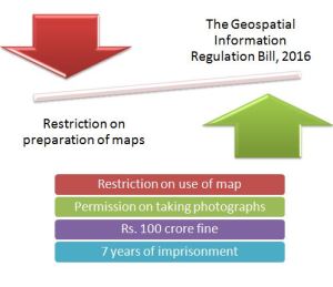
Photo Credit: PlanningTank.com
The Bill is based on the premise that some of the neighbouring countries and some of the international bodies are representing the map of India in a distorted manner. Internet has enabled access to such large number of unauthenticated maps of India.
The draft bill is seeking to make it very difficult for academic study or research based on spatial data as some of the provisions of the bill seeks to make it mandatory for users to get pre-approval from the Security Vetting Authority for any scale of map.
We already have some provisions in existing laws which prohibit from getting geospatial information about the security and vital installations in India. This is already very effective as the general public has not access to the maps generated by Survey of India or National Thematic Mapping Organisation (NATMO) which are of low resolution and mostly on the scale of 1:50000 or 1: 25000. Most of the maps are derived from the base maps generated by Survey of India.
The present bill in its current format will do more harms than good. As this bill propose to regulate the use of geospatial information by Indians rather than natives of other countries. They are free to get the geospatial data from different sources online. Many countries and organisations are providing Geospatial data at a low price or free of any charge.
The Geospatial Information Regulation Bill, 2016 seeks to make is very difficult for the progress and development which is taking place in the field of the geospatial representation of the information which makes information more relevant for analysis. The bill seeks to make it mandatory for anybody to seek permission from the Security Vetting Authority before acquiring, disseminating, publishing or distributing any geospatial information in India.
The draft bill circulated by the Ministry of Home Affairs has many provisions which will make an academic study based on geospatial information more difficult as the definition of gestational information mentioned in the bill is as follows
“Geospatial imagery or data acquired through space or aerial platforms, such as satellite, aircraft, airships, balloons, unmanned aerial vehicles including value added; or graphical or digital data depicting natural or man made features, a phenomenon or the boundaries of the earth or any information related thereto including surveys, charts, maps, terrestrial photos referenced to a coordinate system and having attributes:..”
The definition is so exhaustive that it leaves planners without any map to work in the planning field. This is not limited to planners, but anyone studying or doing research based on geospatial information.
This is the right time when every scholar, professors, planners, architects, civil engineers, geographers, economics, sociologies, and all others who are here to support the free access to geospatial information for research and academic purpose without running from post to pillars in government office should write strongly against the bill and bill the issue in focus so that the bill is not passed in its present form.
Jai Hind!
Shashikant Nishant Sharma